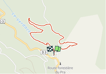
![](/images/other/stat-length.png)
![Tour Wandern Le Castellard-Mélan - Sentier de découverte du Col de Fontbelle - Photo](https://media.geolcdn.com/t/1900/400/a5489b00-5fda-4995-b689-0ad0ef487f71.jpg&format=pjpeg&maxdim=2)
Sentier de découverte du Col de Fontbelle
jalien04
Benutzer
![Länge](/images/other/stat-length.png)
![Maximale Höhe](https://static1.geolcdn.com/siteimages/upload/files/1508320355ic_sort_altitude_max_24dp.png)
![Positive Höhendifferenz](https://static1.geolcdn.com/siteimages/upload/files/1508320355ic_sort_den_pos_24dp.png)
![Km-Effort](/images/other/stat-length.png)
![Min. Höhe](https://static1.geolcdn.com/siteimages/upload/files/1508320355ic_sort_altitude_min_24dp.png)
![Negative Höhendifferenz](https://static1.geolcdn.com/siteimages/upload/files/1508320355ic_sort_den_neg_24dp.png)
![Boucle](https://static1.geolcdn.com/siteimages/upload/files/16400158638029165_repeat_loop_refresh_sync_direction_icon.png)
![Wandern](https://static1.geolcdn.com/sitytour/trail-icons/101.png)
59m
Schwierigkeit : Einfach
![Scannen Sie diesen QR-Code, um die Tour in der SityTrail-Anwendung zu öffnen](https://capi.geolives.com/qq0zvz2zws4bq2lad0pu/sitytour/trails/3266751/qr.png?size=200)
Kostenlosegpshiking-Anwendung
Über SityTrail
Tour Wandern von 2,2 km verfügbar auf Provence-Alpes-Côte d'Azur, Alpes-de-Haute-Provence, Le Castellard-Mélan. Diese Tour wird von jalien04 vorgeschlagen.
Beschreibung
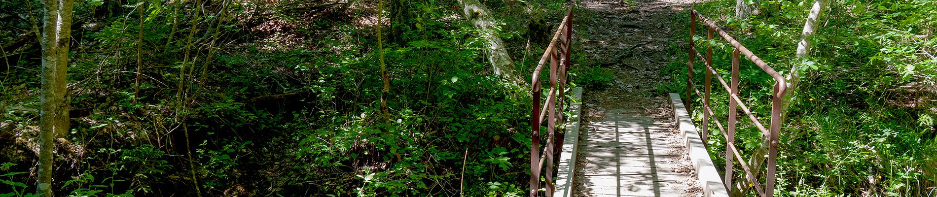
Une agréable boucle qui serpente en sous-bois, dans une ambiance forestière calme et feutrée, rénové en 2021 par la Communauté d'agglomération Provence Alpes Agglomération.
Accès à proximité de la zone d'accueil aménagé du col de Fontbelle.
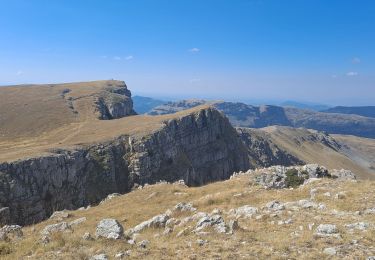
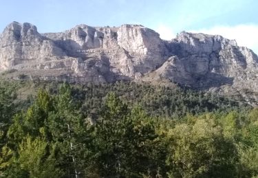
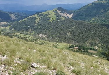
Pour s'y rendre, la belle vallée des Duyes depuis Mallemoisson, vue sur le village médiéval de Thoard, vues depuis le col de l'Hysope sur l'esthétique barre de Géruen et la vallée des Duyes .
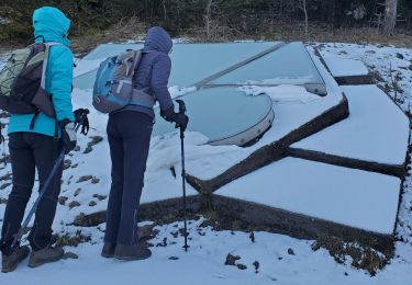
Ort
Kommentare
Touren in der Umgebung
![Tour Wandern Hautes-Duyes - geruen sentier des chamois - Photo](https://media.geolcdn.com/t/375/260/76e6f18d-9f19-4351-821e-ec84b6202ed5.jpg&format=jpg&maxdim=2)
![Wandern Wandern](https://static1.geolcdn.com/sitytour/trail-icons/101.png)
Wandern
![](/images/other/stat-length.png)
![](https://static1.geolcdn.com/siteimages/upload/files/16400158638029165_repeat_loop_refresh_sync_direction_icon.png)
![Tour Wandern Authon - 20180912_Monges_Authon_Boucle_Sommet Coste belle - Photo](https://media.geolcdn.com/t/375/260/ext.jpg?maxdim=2&url=https%3A%2F%2Fservices.sitytrail.com%2FGeolivesWS%2FDownloadMedia.ashx%3FTrailID%3D1038487%26Media%3D0586817d-9cc9-405c-aa4b-393c8043fb42.jpg)
![Wandern Wandern](https://static1.geolcdn.com/sitytour/trail-icons/101.png)
Wandern
![](/images/other/stat-length.png)
![](https://static1.geolcdn.com/siteimages/upload/files/16400158638029165_repeat_loop_refresh_sync_direction_icon.png)
![Tour Wandern Hautes-Duyes - Crête de Géruën descente sud Est - Photo](https://media.geolcdn.com/t/375/260/896db46e-982b-48f6-bf8f-c5ab98c282d0.jpg&format=jpg&maxdim=2)
![Wandern Wandern](https://static1.geolcdn.com/sitytour/trail-icons/101.png)
Wandern
![](/images/other/stat-length.png)
![](https://static1.geolcdn.com/siteimages/upload/files/16400158638029165_repeat_loop_refresh_sync_direction_icon.png)
![Tour Zu Fuß Authon - SityTrail - Les Monges au départ de Authon - Photo](https://media.geolcdn.com/t/375/260/dd7c9a01-878d-406c-bd6f-593236ad6bc5.jpg&format=jpg&maxdim=2)
![Zu Fuß Zu Fuß](https://static1.geolcdn.com/sitytour/trail-icons/100.png)
Zu Fuß
![](/images/other/stat-length.png)
![](https://static1.geolcdn.com/siteimages/upload/files/16400158638029165_repeat_loop_refresh_sync_direction_icon.png)
![Tour Wandern Hautes-Duyes - sommet Geruen et son pas - Photo](https://media.geolcdn.com/t/375/260/3f9beb02-93ed-438f-917d-d2a6ab1524ae.jpg&format=jpg&maxdim=2)
![Wandern Wandern](https://static1.geolcdn.com/sitytour/trail-icons/101.png)
Wandern
![](/images/other/stat-length.png)
![](https://static1.geolcdn.com/siteimages/upload/files/16400158638029165_repeat_loop_refresh_sync_direction_icon.png)
![Tour Wandern Authon - AUTHON Faissal La Croix de Vey ré Sommet de Chine o - Photo](https://media.geolcdn.com/t/375/260/ext.jpg?maxdim=2&url=https%3A%2F%2Fstatic1.geolcdn.com%2Fsiteimages%2Fupload%2Ffiles%2F1553511878bg_sport_marche.png)
![Wandern Wandern](https://static1.geolcdn.com/sitytour/trail-icons/101.png)
Wandern
![](/images/other/stat-length.png)
![](https://static1.geolcdn.com/siteimages/upload/files/16400158638029165_repeat_loop_refresh_sync_direction_icon.png)
![Tour Wandern Le Castellard-Mélan - corbeau grande aiguille 1086m20.5kms - Photo](https://media.geolcdn.com/t/375/260/4e4885ef-71be-40f7-a111-067ac607986b.jpg&format=jpg&maxdim=2)
![Wandern Wandern](https://static1.geolcdn.com/sitytour/trail-icons/101.png)
Wandern
![](/images/other/stat-length.png)
![](https://static1.geolcdn.com/siteimages/upload/files/16400158638029165_repeat_loop_refresh_sync_direction_icon.png)
![Tour Wandern Authon - AUTHON. GROTTE. COL DE L AIGUILLE O L - Photo](https://media.geolcdn.com/t/375/260/ddbf7ae4-52a3-4044-bf29-d39533b6071a.jpg&format=jpg&maxdim=2)
![Wandern Wandern](https://static1.geolcdn.com/sitytour/trail-icons/101.png)
Wandern
![](/images/other/stat-length.png)
![](https://static1.geolcdn.com/siteimages/upload/files/16400158638029165_repeat_loop_refresh_sync_direction_icon.png)
![Tour Wandern Authon - Faissal costebelle monges 825m 15kms - Photo](https://media.geolcdn.com/t/375/260/046e609e-5db9-4f03-96f9-56a1dcdd4ced.jpg&format=jpg&maxdim=2)
![Wandern Wandern](https://static1.geolcdn.com/sitytour/trail-icons/101.png)
Wandern
![](/images/other/stat-length.png)
![](https://static1.geolcdn.com/siteimages/upload/files/16400158638029165_repeat_loop_refresh_sync_direction_icon.png)